Specification:
Condition: 100% Brand New
Item Type: Marine Navigator
Material: Aluminum Alloy + ABS.
Color: As Pictures Shown
1. This equipment is a general-purpose shipborne AIS equipment, hard aluminum alloy shell, XP6 waterproof, and can exchange navigation and ship data information with other ships and shore stations.
2. This equipment complies with IMO's MSC74 (69) appendix 3.A.694.ITU-RM.137-3 and DSCITU-RM.825, and complies with IEC61993-2 (type test standard), IEC60945 (EMC and environmental conditions).
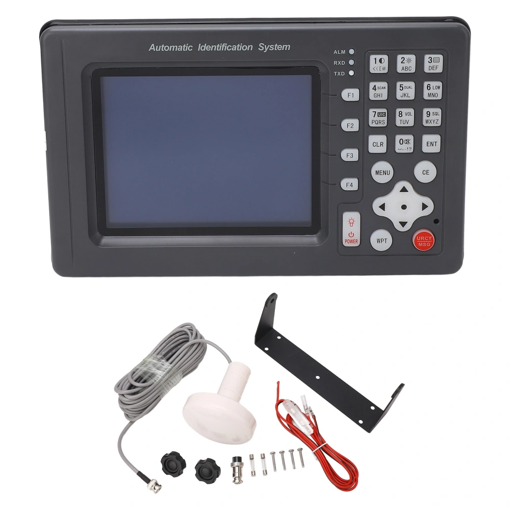
3. It is composed of transponder unit, display control unit, VHF and GPS antenna and related accessories.
4. The repeater unit includes a VHF transmitter, two TDMA receivers, a 70-channel DSC receiver, an interface, communication processor, built-in GPS receiver, etc.
5. AIS ensures the safety of navigation by automatically exchanging navigation information with other ships or shore stations.
Static Data:
Call Number
Ship Name
Maritime Mobile Service Indentify(MMSI)
IMO Number
Ship Length and Width
Ship Type
The Position of the GPS Antenna on the Ship
Dynamic Data:
Ship's Position
UTC
COG
SOG
Ship Heading
Navigation Status
Manual Input Code
Rate of Turn
Voyage Data:
Draught
Dangerous Cargo Type
Port of Destination and Estimated Time of Arrival
Security-Related Short Messages:
Technical Index:
Whole Machine Part:
Radio Frequency Unit: 1 Transmitter, 2 Receivers
Frequency Range: 156.025-162.025MHz
Channel Spacing: 25KHz
Modulation Method: GMSK9600Bps, FSK1200Bps
Frequency Error: 1000Hz
Display Screen: TFT True Color 6in / 15.24cm LCD Screen
Positioning Time: <120s
Positioning Accuracy: Approx. <10m / 10.9yd
Working Voltage: DC12V or AC24V
Working Temperature: -15 - +55
AIS Transmitting Part:
Carrier Power: 33dBm1.5dB
Modulation Spectrum:
<-25dBw
<-60dBw
Modulation Accuracy:
<3400Hz (Bit 0,1)
2400Hz480Hz (Bit 2, 3)
2400Hz240Hz (Bit 4-199 or 00001111 Bit Format)
1740Hz175Hz (for 0101 Bit Format)
Spurious Emissions:
- 36dBm (9KHz-1GHz)
- 30dBm (1GHz-4GHz)
AIS Receiving Part:
Reference Sensitivity: -107dBm (Packet Error Rate 20%)
Strong Signal Receiving Capability: -77dBm (Packet Error Rate2%)
- 7dBm (Packet Error Rate <10%)
Co-Channel Suppression:> 10dB (Packet Error Rate20%)
Adjacent Channel Selectivity: >70dB (Packet Error Rate 20%)
Spurious Immunity:> 70dB (Package Error Rate20%)
Intermodulation Immunity: >65dB (Packet Error Rate 20%)
Blocking: >86dB (Package Error Rate 20%)
Spurious Emission:
- 57dBm(9KHz-1GHz)
- 47dBm(1GHz-4GHz)
Features:
1The automatic ship identification system has many functions, which can continuously and autonomously receive and transmit AIS data information, and can also display the AIS data information of ships equipped with AIS equipment around the ship. 2The static data of the ship automatic identification system includes: MMSI, ship name, call sign, IMO number, ship type, ship size, GPS antenna location, ship registration, etc. 3The dynamic data of the ship automatic identification system includes: latitude and longitude, ship speed, heading, turning rate, bow, bearing, distance, etc. The navigation data includes: navigation status, draught, type of dangerous goods, destination and expected time, etc. 4For AIS target ships within the set range, the automatic identification system can carry out light and voice prompts and alarms, and the alarm sound will continue to change as the distance approaches, supporting the sending and receiving of emergency information. 5There is an alarm function. When a ship with a speed greater than 2 knots enters within a range of 0.110 nautical miles from the ship, the red indicator light on the display terminal will flash, and the speaker will emit an alarm sound: "Directiondegrees, distancenautical miles away The boat is approaching. Please avoid it carefully." 6There is a target ship information display function, the list can display the target ship (display distance, azimuth and 9digit identification code, the vector display target ship can provide a range of 1100 nautical miles, and it also supports the display of the target ship on the electronic chart. 7Support GPS navigation function, use 6inch color LCD display, can display the national coastline chart, place name information data and waypoints, routes and track settings, edit and delete operations. 8Can display ship position, ship speed, course, track, time, date, etc., display the direction, distance and estimated time of arrival of the destination, and arrive, yaw, alarm and prompt when navigating the destination. 9Supports the storage and recall of waypoints, routes, and tracks. It can store 10,000 waypoints, 10,000 marker points, 200 routes, and 200,000 track points.
Package List:
1 x Marine Navigator
1 x GPS
1 x Power Wiring
1 x Base Bracket
4 x Mounting Screws
2 x Knob
4 x Screw Washer
2 x Fuse
1 x Manuals