Specification:
Item Type: GPS Chart plotter
Material: ABS+silicone
Screen Type: Color TFT LCD Display
Screen Size: 7 inches
Resolution: 800 x 480
Screen Brightness: 500cd/
Languages: English, Simplified Chinese, Traditional Chinese, Vietnamese, Malay, Korean, Turkish, Thai, Greek, Indonesian, Japanese, Burmese, Arabic, Spanish, French, Persian
Picture Mode: Standard chart, simple chart, full screen chart, navigation data, satellite ephemeris, 3D navigation
Storage Capacity: 50,000 waypoints, 50,000 mark points, 500 routes, 200 points per route, 1,000 tracks, 1.6 million track points
Interface: 2 way NMEA0183 output, 2 way NMEA0183 input (independent of each other, baud rate can be set independently)
WIFI: 802.11 b/g/n
Working Temperature: -15-+55
Storage Temperature: -20-+60
Waterproof Grade: IPX6
GNSS
Receive Channel: 72 channels
Receiving Frequency Band: GPS L1: 1575.42MHz; BDS B1: 1561.098MHz
Positioning Accuracy:
GPS and BDS 2.5m (CEP50%, open field)
GPS: 5m (CEP50%, open area)
BDS: 5m (CEP50%, open area)
Speed measurement Accuracy: 0.1m/s (50%at10m/s)
First Positioning Time: Less than 30 seconds (cold start), less than 1 second (warm start)
Compliant With Standards: IMO A.694(17) , IMO MSC 112(73), IEC 61108-1, IEC 61162-1, IEC 60945
Introduction:
- 7in color LCD screen, 800480 resolution, bright, wide viewing angle.
- Support the display of various chart data such as for C MAP (MAX).
- Classic mode and practical mode dual operating system, free to switch.
- Built in BDS, GPS dual-mode high-precision positioning module, the positioning accuracy is stable and reliable.
- Support multi language display, which can meet the usage requirements of different user groups.
- Multi-screen display mode for users to choose and switch freely.
- Support network connection to realize online software upgrade.
- Advanced intelligent voice technology, intelligent broadcast of operational content, alarm content, etc.
Features:
1Precise Positioning: GNSS chart plotter supports BDS, GPS dual mode positioning, combined with self developed SOG and COG filtering algorithm, high receiving sensitivity, accurate position. 2Dual Chart System: Support for C MAP MAX and for XINUO MAP dual chart system, users can switch independently. Built in global charts, providing regular updates of XIUO charts. 3Large Capacity Storage: Using a high speed and stable flash chip, the device supports storage of 50,000 waypoints, 50,000 mark points, 500 routes, 1,000 tracks, and 1.6 million track points. 4Custom Settings: Support to display your own ship at any position on the screen to expand the navigation field. Also supports custom data names, symbol styles and colors. 5Waterproof Shell Design: Plastic shell design, waterproof, dustproof, anti interference, fast heat dissipation. The waterproof and dustproof grade is IPX6. 6Internet Services: Connect to a mobile network to upgrade software and diagrams online. Combined with IoT technology, it can easily support function expansion and help smart shipping.
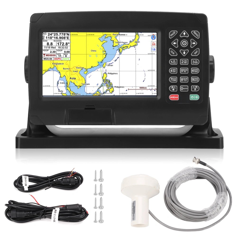
Package List:
1 x GPS Chart Plotter
1 x GNSS Antenna
1 x 8 Core Data Cable
1 x 2 Core Power Cord
1 x Mounting Base Bracket
2 x Fixed Knob
4 x Base Fixing Screws
4 x Small Screw
1 x User Manual