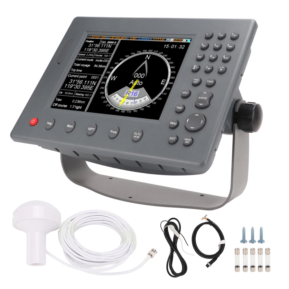
Specification:
Item Type: GPS Chart Plotter
Material: ABS
Display Size: 8in
Resolution: 640x480
Display Mode: TFT LCD color display
Operation Mode: Adjustable backlight keys, shortcut keys, T9 keyboard
Language: English
Voltage Range: 24V DC%20
Power Supply: High performance, fully isolated PWM control power supply
Power Consumption: 15W
Compass Safety Distance: 1.5 m
Other Functions: Tide and compass interface; AIS display and alarm, AIS information, vessel management (if AIS is entered)
Input/Output: GPS/BDS (GGA, GLL, GSA, RMC, VTG, AIS(VDM))
Memory Card: Update software and diagrams, import and export data
Data Display:
Suspension Data: Ship latitude and longitude, fish area, speed, heading information; navigation information
Ambient Temperature: -15-55
Protection Class: IP20
AIS Function:
Emission Channel: 1 ch
Receive Channel: 2 ch
Receiving Frequency: 156.025-162.025MHz
Default Channel: CH2087, CH2088
Bandwidth: 25KHz
Modulation Method: GMSK
Receive Sensitivity: Better than -107dBm
RF Output Power: 2 W
Transmitting Channel: 87B/161.975MHz
Receiving Channel: 88B/162.025MHz
GPS receiver adopts high speed stabilization technology
GPS Receiver Positioning Accuracy: 15m, accuracy 95%
GPS Receiver Positioning Time: 45s for cold start, 15s for hot start
Navigation Performance:
Waypoints And Markers: 6000 points
Routes: 200 routes, each route contains 99 waypoints
Tracks: 200 routes
Includes tide and compass
Intelligent anticollision
Interface:
- GPS Output: RS 422, NMEA0183, 4800bps
- AIS Input And Output: RS 422, NMEA0183, 38400bps
- Sonar Input And Output: RS 422, NMEA0183, 115200bps
- GPS Antenna Interface: BNC base, impedance 50
- VHF Antenna Interface: UHF base, impedance 50
- Power Interface: 24V DC%20
Features:
1Two Positioning Methods: Support GPS and Beidou precise positioning. 2D positioning and 3D positioning are supported. Ship positioning usually adopts two dimensional positioning. 2Stable Signal: Built in high sensitivity GPS receiver board and GPS antenna, GPS receiver adopts high speed stabilization technology, accurate positioning. 200 routes, each route contains 99 waypoints. 3Multifunction: GPS, chart, tide, compass, etc., built in AIS, can be connected to an external depth sounder, fish finder and wireless AIS fishing net buoy, Flash quick start technology, stable performance. 4AIS Function: GPS Navigator combines AIS target information and AIS group management. Complies with AIS Class B Shipborne Equipment Standard (IEC 62287 1) 5TFT LCD Screen: Color display is suitable for sailing in the sun and at night. Intuitive menus allow you to quickly find the information you need, when you need it. Depth readings, positions can be monitored on the screen. 6Easy Operation: Automatically connect to AIS wireless network when power on, T9 numeric keyboard and shortcut keys, support English, support pinyin and stroke Chinese characters input. Quick update via external memory card.
Package List:
1 x GPS Chart Plotter
1 x Fixed Bracket
1 x Antenna
1 x 2 Core Power Cord
1 x Data Cable
5 x 5A Fuse
2 x Fixed Knob
3 x Fixing Bracket Screw
1 x Manual